PYAA06 today Nice stable conditions for an East coast trip to the Caribbean


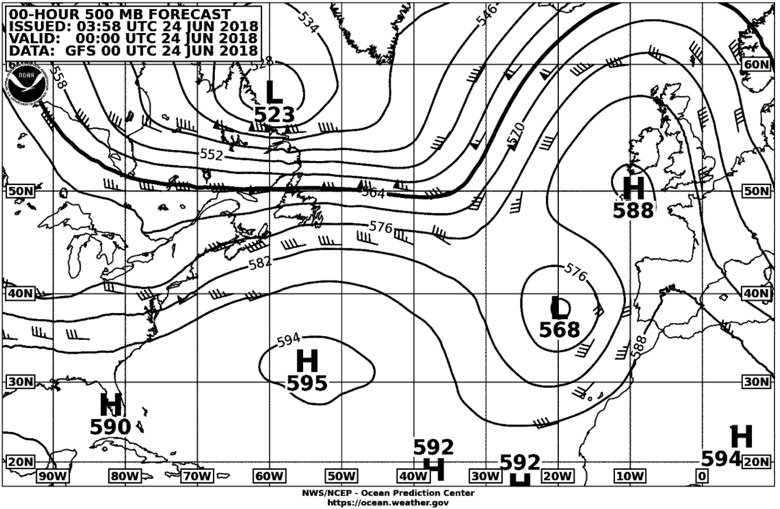
This is an upper air chart (500MilliBar) which shows the air movement that will affect the surface conditions. This is important for forecasting development of storms. It is useful anywhere in the Atlantic above the tropics. The surface winds are usually half the speed of these upper level winds. You can see if the weather at the surface is going to get worse. (L refers to low altitude, not low pressure,)
Of course you need to be able to understand these charts. The best book is Steve Dashew’s Mariners Weather Handbook. It is so valuable that a new copy with CD costs $150+. The CD is a copy of the book. I wouldn’t be without it. There is nothing that compares.
June 2014: join SSCA and download a free copy of the first edition. Or go here http://setsail.com/mwh.pdf
Thank you Steve and Linda for making this book available for free.
Hurricane and Storm avoidance.
You need to see the NWS charts for planning a trip to avoid bad weather in the tropics. GRIB charts are not reliable for the tropics - they are generated by computers and unreliable and should not be used for hurricane avoidance tactics.
GRIB charts are very small and are cheaper to send to the yacht, but they are not real weather charts, only computer models of what might happen. There are five plus different models and weather forecasters look at all of them and do a best fit is based on their experience and hand draw the NWS charts you see here.


RTN