

Let’s talk about Ocean Navigation.
You need only a few simple charts while crossing the Ocean. One large scale chart for the entire journey on one screen, and several for the Islands you may stop at.
Charts are to guide you to the destination, but as you get closer you must rely upon visual sights of the landmarks, and information about the depth of water and obstructions.
GPS plotters are just for entertainment, at least that is what the makers ask you to agree with. Read their disclaimers. These are not government issued charts, so they are not necessarily an accurate representation of the conditions, nor are they up to date with light changes etc.
GPS plotter charts are good for planning, but don’t trust them for position near Islands. My GPS chart once directed me right over the top of an island in the Virgins! It was half a mile in error.
Yiou should know that unless the destination is used by the Navy, the chart may have last been verified by Captain Cook! I kid you not. Some of the Island charts are dated from the 1800s, and haven’t been surveyed since then.
A few private individuals, like Don Street have done their own surveying and produced up to date charts (The Iolaire series from IMRAY.) And some people have written guides to the Islands with photographs. But your plotter uses traditional charts, which are not to be relied upon close to any Island that has not been surveyed since 1960 or so. So, as you get within sight of the land, start using your eyes and get local info from the harbor authorities or yachties who are already there.
Some electronic charts are better than others. Raster charts have the same information on bottom conditions as the paper charts. Depth and bottom information is very dense. (Vector charts have much less information on bottom conditions.)
We need to know where the sandy bottom is located, not the facilities in the local marina—that you can get over the VHF after you arrive.
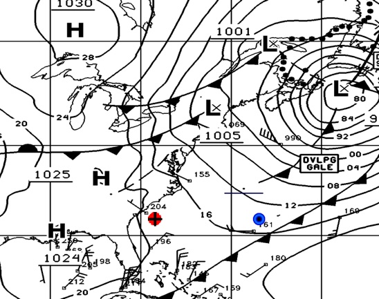
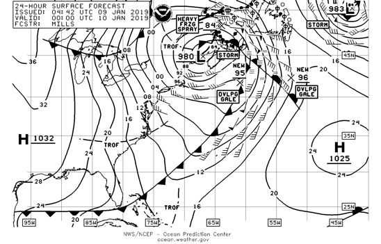
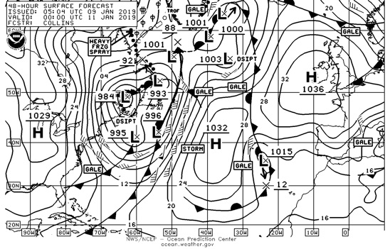
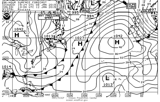
And so you see how these NOAA charts, properly understood, give advance warning of adverse conditions.
You can download these charts from NOAA or from a SSB radio.
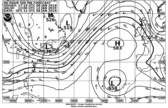
Most navigation programs use only GRIB files to show winds and currents, not upper atmosphere. It is impossible to see more than 24-36 hours ahead using GRIB charts, because the data is just machine generated and with no meterologist involved in interpretation, the data is not dependable. NOAA warns people not to depend on GRIB data except for immediate analysis and short term look ahead.
It will take some studying to understand the 500 millibar chart and the effects the upper atmosphere has on future weather at deck level.
To be able to understand these charts, the best book is Steve Dashew’s Mariners Weather Handbook. It is so valuable that a new printed copy with CD costs $150+. The CD is a copy of the book. I wouldn’t be without it. There is nothing that compares.
But you can go go here http://setsail.com/mwh.pdf

Thank you Steve and Linda for making this book available for free.
So, navigate across Oceans using weather charts.
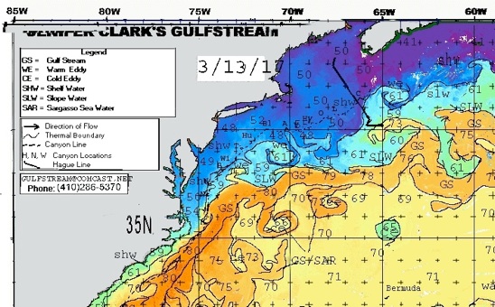
You will need to know where the eddies are located in the Gulf Stream, sometimes you have to change course to get on the side which gives you a lift, otherwise the current may run against you at several knots. On the way home one year I got on the wrong side and my SOG was down to 2 kts under full power.
These charts are commercially available, but sometimes you can find them for free on the web.
Here is a commercial site Jennifer Clark’s Gulfstream. Her company provides routing information for cruisers fo $250 per trip. A single chart is $50 and these are produced weekly.
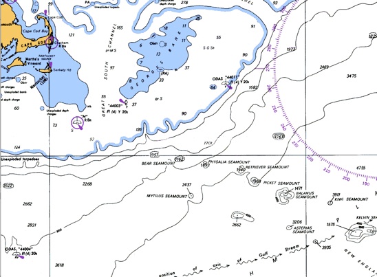
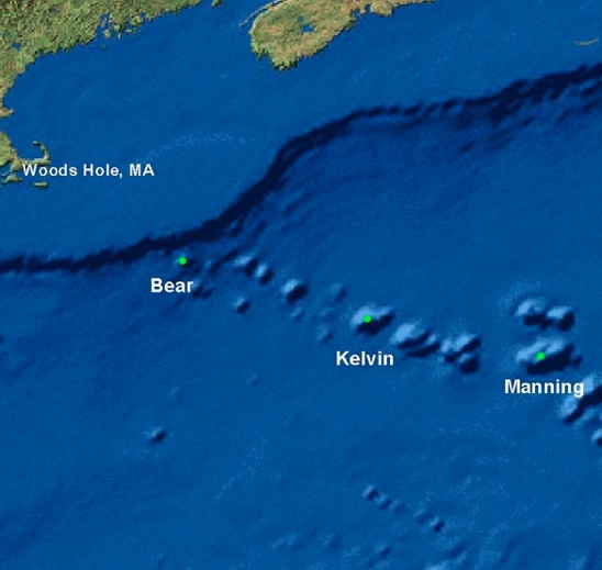
From the regular Ocean charts you need to know where the sea mounts are located so you can give them a wide berth. Even though they may be hundreds of feet below you, the ocean currents are affected and the surface can be very nasty for several hours as you bump bump bump across them. Here are the locations of the New England Sea Mounts off Cape Cod.
You should plot your position at noon every day using GPS, or other. And then dead reckon between fixes if you want to avoid a patch of ocean. There is no need to run the chart plotter all day long, and the computer, because you will have to put back into the batteries 20% more than you take out. On overcast days you may be limited in the amount of energy you can collect. A large solar array such as I have 10 feet x 4 feet will only produce 120 A-hrs a day into an almost fully charged battery. A computer and plotter can use 4 Amps, so that’s 4x12(hrs) or 48 A-Hrs a day which requires 58 A-hrs from the solar panels. Refrigeration will take about the same, then there are lights and radio.
A 16” chart plotter from Raymarine takes 45 watts, so does a 17” macBook. That means 4 AMps for either. If they are on 12 hours a day that’s 48 A-hrs each. The most you will be able to put back in the batteries is about 120 A-hrs a day if the sun shines.
On a sailboat, just turn the plotting system on a few times a day for 15 minutes or so. And use the computer and radio to collect perhaps an hour of weatherfax charts a day.
I used a Mac PowerBook for the Caribbean trip which was a chart plotter with about 400 charts in it. I used the same PB to collect weatherfax charts. I can still use a PB with a 17” display for those same nautical charts. It consumes 45 watts while charging. I could also use a 17” iMac but that draws 8 amps, twice as much as the PB.
What else do you need for Ocean navigation?
A GPS with large display that can be seen by the helmsman or on-watch. Two backup GPS that will run on small batteries.
A calibrated compass.
A log to measure speed and distance.
A barometer.
A log book.
A good SSB radio and antenna system.
A VHF radio with DSC.
Autopilot or wind vane.
Depth sounder to 600 fathoms.
Not necessary:
Radar
AIS
Wind instruments.
Nice to have:
Sat phone for downloading weather info, and talking to the shore.
A handheld satphone costs $800-2500 to and $1 a minute.You can rent one for Ocean crossings for a few hundred dollars.
I used a satellite system that covered the Caribbean for that voyage. It cost $25 a month plus $1.15 a minute of use (voice or data.) Data was limited to 4800 baud. It cost me $10 a day to download my weatherfax picture via e-mail.
When you get to the Islands there is always an internet connection near the anchorage. If you have a wi-fi high gain dish antenna you can connect to a shore wi-fi up to two miles away. Otherwise use the internet cafes when you go shopping. Cellphone is getting cheaper, and you can always use skype and the internet. With a skype phone number, family can simply dial your phone number and the computer will ring. I use skype on my iPod which has no phone service, and it sounds to people like an ordinary phone call. You can also do face to face video with skype. Charting
The iPad can also be used with Caribbean marine charts for navigation (Imray.com). The set of Eastern Caribbean charts for the iPad is $47. IOS device use hardly any power compared with SSB and Ham equipment. If you get a Bad Elf GPS pro designed for bluetooth ipads and Android device. Then you won’t need a 3G version of the ipad. In fact it will work much faster when at sea if you use the Bad Elf GPS Pro. Also an extension so that the GPS antenna can be in the clear. Using this GPS will keep the iPad power consumption at a minimum compared with using the built in GPS which uses five times the power. As of today Jan 7 2019the Bad Elf Pro app is available on the apple APPS store for ios devices for free.